Skip to m'Loo Down Under
 OK, It's now official-- I have seen everything...
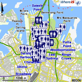
The Aussie government has published the National Public Toilet Map online, driven by the WhereIs mapping engine.
The map shows the location of more than 14,000 public toilet facilities across Australia. Details of toilet facilities can also be found along major travel routes and for shorter journeys as well. Useful information is provided about each toilet, such as location, opening hours, availability of baby change rooms, accessibility for people with disabilities and the details of other nearby toilets.
In what has to be the most bizarre usage of the .GPX geocaching file fomat to date, the site's FAQ page contains this entry:
Adding a toilet to your GPS devicevia The Australian Gov't Dept of Health and Aging
On the toilet details page, the approximate latitude and longitude of the toilet is displayed underneath the address. Make sure your GPS device is set to display decimal degrees and is set to use the WGS 84 (World) or GDA 94 (Australia) datum. You can then enter these decimal numbers into your GPS and save them as a waypoint (some GPS devices may allow you to choose a toilet icon). Once you have selected your favourite areas, simply click on the "Download your favourite toilets and areas in GPX format" link in your "My Toilet Map" section. The file will be in ".gpx" format and should easily integrate with your GPS device software.

<< Home